|
The
Grand Canyon - Arizona
by Carl Burnham
 Upon visiting the Grand
Canyon area for the first time, it's sheer magnitude can
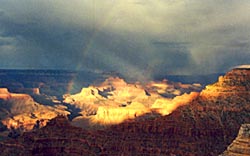
be overwhelming. As I photographed here after a late afternoon
thunderstorm, a rainbow appears as the sun reveals a portion
of the Canyon. For this feature, we traveled via our
RV, staying along Route 66 in Williams. (see our previous
feature on this area of Route
66).
When planning your trip, multiply your time by two. You will
want to stay longer to see all the hidden attractions and
area towns that make the Grand Canyon a treasure to experience
again and again. We plan to visit the area again to feature
more of the surrounding towns in a future segment. Upon visiting the Grand
Canyon area for the first time, it's sheer magnitude can
be overwhelming. As I photographed here after a late afternoon
thunderstorm, a rainbow appears as the sun reveals a portion
of the Canyon. For this feature, we traveled via our
RV, staying along Route 66 in Williams. (see our previous
feature on this area of Route
66).
When planning your trip, multiply your time by two. You will
want to stay longer to see all the hidden attractions and
area towns that make the Grand Canyon a treasure to experience
again and again. We plan to visit the area again to feature
more of the surrounding towns in a future segment.
The Grand Canyon was first
explored in 1853 and reported as "valueless". Today,
this national park now attracts well over 5 million visitors
a year to experience its' stark wonders and beauty. The park
contains several layers of the oldest exposed rock on earth,
and is part of the "Grand
Staircase" formation
which reaches into Utah and Arizona. Formed several million
years by the deep flowing waters of the Colorado River, the
canyon is a mile deep and over 190 miles wide covering over
1.2 million acres.
 Most tourists go to the South Rim, which is more accessible than the North Rim. The physical distance is ten miles between the two rims, with the North Rim being 1,000 feet higher. By road, the two rims are 215 miles apart. The roads to the North Rim are closed from mid-October to mid-May due to the eleven feet snows typically for that area. Most tourists go to the South Rim, which is more accessible than the North Rim. The physical distance is ten miles between the two rims, with the North Rim being 1,000 feet higher. By road, the two rims are 215 miles apart. The roads to the North Rim are closed from mid-October to mid-May due to the eleven feet snows typically for that area.
Within the Kaibab Forest near the entrance are tall stands of white-barked Aspen trees. The young Aspen tree shoots are a favorite food of the elk to munch on. The highest point in the Grand Canyon is Point Imperial.

Grand Canyon "Rainbow"
Limited Edition T-Shirts!
Zoom In For Closeup
Along the Cape Royal area, be sure to glimpse Angel's Windows which has a natural limestone arch. At Grand Canyon Lodge, which is directly on the edge of the North Rim, you can see out large viewing windows at the panoramic landscape. Mule rides are popular on both rims for a half day or all day rides. Be sure to register well in advance. When going to overlooks, be sure to time your visit either early or late in the day to capture the best photographs.
At Williams,
where we stayed at the RV
Railside Ranch Campground, are numerous
old motels, businesses and an historic downtown
area. Read our other feature
on Route
66.
 In earlier days, Williams was referred
to as the "Little Las Vegas" due
to the many motel neon signs in town, and
is the entranceway to the Grand Canyon (about
60 miles north) from Interstate 40. We visited
the Route
66 Magazine headquarters here. The Jeff
Gordon National Fan Club is located in town.
Several good restaurants along the "strip" include
Cruisers (full of memorabilia)
and Rod's Steak House (tasty and affordable,
as it has been for over 50 years). The Grand
Canyon Railroad operates here and provides
rides to the Grand Canyon. In earlier days, Williams was referred
to as the "Little Las Vegas" due
to the many motel neon signs in town, and
is the entranceway to the Grand Canyon (about
60 miles north) from Interstate 40. We visited
the Route
66 Magazine headquarters here. The Jeff
Gordon National Fan Club is located in town.
Several good restaurants along the "strip" include
Cruisers (full of memorabilia)
and Rod's Steak House (tasty and affordable,
as it has been for over 50 years). The Grand
Canyon Railroad operates here and provides
rides to the Grand Canyon.
To the west of the Grand Canyon
is the Havasu Canyon, with extraordinary waterfalls and side
canyons. Arrangements to visit here have to be made through
the Havasupai Indian Reservation, many months in advance.
Further north above the North Rim is Lake Powell where you
can explore side canyons by boat. We decided to go to the
South Rim to explore the scenic views along the rim.
At the South Rim, we drove the
full extent of the East Rim Drive. Be sure to stop first
at the Visitor Center and then the Grand Canyon Village store.
If you plan to visit several national parks like us, save
money and get a Golden Eagle Passport. It is only fifty dollars
for a full year's entry to any national park or monument.
Compare that to twenty dollars per visit per park.
In venturing east on East Rim
Drive, we stopped at Grandview Point and Moran Point (named
after the painter Thomas Moran). From these points you can
see into the Horseshoe Mesa area and distant peaks such as
Solomon Temple and Vishnu Temple. At the Tusayan Ruins, you
can see remnants of Pueblo Indians who villaged here in the
late AD 1100s. A museum here explains more of their culture,
which thrived here for 1,300 years. At Lipan Point, you can
see a good view into the Colorado River gorge. At Desert
View, we could see more of the Colorado River's rapids and
views of Cedar Mountain to the east. It is also the location
of the Watchtower, which is a castle-like stone structure
built on the cliff in the 1930s and an area campground and
store. You can camp overnight below the Rim with an approved backcountry permit from
the Backcountry Office. It is usually recommended to spend
the night when hiking into the canyon all the way to the
Colorado River. There are designated campsites below the
rim and also Phantom Ranch which houses a lodge and dormitory
rooms (reservations are required well in advance of your
scheduled stay). The two maintained hiking routes from the
South Rim are the South Kaibab Trail and Bright Angel Trail.
The South Kaibab Trail provides more scenic views and is
shorter, but does not provide any water source or campsites
along the way as the Bright Angel Trail does. We didn't have
time to do an overnight hike this time, maybe the next trip...
There are also RV and tent campgrounds and lodging available
above the rim.
The next day, we went on a ranger
hike along the Rim Trail (we highly recommend it). She talked
about all the wildlife and plants that you typically find
along the trail, and how inter-connected nature is. We learned
about pine (or Pinon nuts) and Juniper seeds and how animals
rely on them. The pine nuts (quite tasty) are expensive in
the local stores due to the difficulty of getting a large
amount without getting sticky pine sap on you. We saw several
mule deer meandering around the Grand Canyon train station
and a grey fox near the exit of the park. If visiting along
the North Rim, you may see the long-eared Kaibab squirrel,
which is the only place in the world to find it. We spent
some time touring the West Rim Road. This is done by free
shuttle buses that the park service provides. Vehicles are
not allowed in this section. We stopped at several points
including Hopi Point to view the sunset. Due to the problem
of pollution (which drifts from surrounding metropolitan
cities) and a scheduled forest fire taking place, it was
a bit hazy. Be sure to visit The
Grand Canyon web site for detailed information.
We spent an afternoon exploring Meteor Crater where the force of a
meteor about 49,000 years ago created a hole 570 feet deep
and over 4,000 feet wide. The bottom of the crater is big
enough to hold 20 football fields. The crater is deep enough
to engulf a 60-story building. The museum contains numerous
facts on meteors, with fragments from all over the world,
along with memorabilia from various space missions. Astronauts
used to train here at the bottom of the crater to simulate
conditions on the moon. You can also view the remnants of
old mine shafts here from the early 1900s. An RV park is
nearby for campers and remnants of old Route 66 (mostly a
rancher road here) can be seen. The area is about 25 minutes
from Winslow.
We next drove the next day
to nearby Walnut Canyon National Monument (close
to Flagstaff) which contains numerous cliff dwellings
left by an ancient Indian tribe (the Sinagua Indians).
The trail takes about an hour to hike through. Be sure
to visit before the late afternoon. The trail closes
at 4 p.m. Remains of buildings are also located here
next to a museum (and another ruin is one mile north
of the Flagstaff Mall on Highway 89). About 15 minutes
north from this Monument on Highway 89 is the Sunset Crater Volcano National Monument.
You can see the result of dramatic lava flows here from a
volcano that erupted around 1100 A.D. and some ancient Indian
ruins. Further north, see the Wupatki National Monument,
with Indian masonry pueblo ruins.
Top of
Page
|

